Edwards Aquifer Land Use / Land Cover
Edwards Aquifer land use/land cover metadata (spatial data layer).
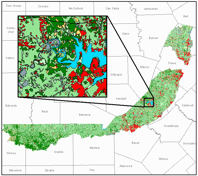
Table of Contents
- 1 - Identification Information
- 2 - Data Quality Information
- 3 - Spatial Data Organization Information
- 4 - Spatial Reference Information
- 5 - Entity and Attribute Information
- 6 - Distribution Information
- 7 - Metadata Reference Information
The following text conforms with the hierarchy of data elements in the FGDC Content Standards for Digital Geospatial Metadata. This GIS layer supersedes all earlier copies, translations or coverages of the Air Quality Monitoring Stations coverage which may have been made by the Texas Commission on Environmental Quality (TCEQ).
- Citation:
- Originator: U.S. Geological Survey (USGS), National
- Mapping Division, Rocky Mountain Mapping Center
- Publication_Date: 200312
Title: Edwards Aquifer Land Use / Land Cover
Geospatial_Data_Presentation_Form: map - Publication_Information:
- Publication_Place: Denver, CO Publisher: USGS
- Description:
- Abstract:
This layer delineates the land use/land cover (LULC) polygons for the Edwards Aquifer Project in Texas from the years 1995 and 1996. Attribution of the polygons is based on a modified Anderson classification schema. LULC classification was done to Level 3 of the classification schema and a new category of Mixed Forest/Shrub was added to better represent the land cover of the area. Fieldwork was performed prior to compilation to gather local data and relate aerial photo images to corresponding ground features. Because of the stunted or lower tree growth common in this region it was difficult at times to differentiate between Forest, Mixed Forest/Shrub, and Shrub. It should be noted that much of the Planted/cultivated land is highly managed pastureland. A detailed description of the schema can be found in the Supplemental Information Section. All the LULC data was collected from color infrared DOQQs and high-resolution (1:40,000-scale) aerial photography. The minimum mapping unit used for delineating a polygon is 5 acres and the minimum polygon width is 125 feet.
Certified as Level 1 - Complies with National Map Accuracy Standards for 1:24,000-scale maps. According to this standard, 90% of well-defined features tested must be within 12 meters. The layer also complies with all TCEQ Agency Standards. - Purpose:
The USGS through an agreement with Texas Commission on Environmental Quality (TCEQ) has collected the LULC data sets for the Edwards Aquifer. The TCEQ intends to use this data to monitor the water quality impacts from land development in the Edwards Aquifer area. - Supplemental_Information:
LAND USE/LAND COVER CLASSIFICATION
Modified Anderson Classification
Category Definitions
February 12, 2001
Version 1.4
1.0 WATER - area covered by water, snow, or ice with less than 25% vegetated or developed cover, unless specifically included in another category
1.1 Open Water - all areas of open water with less than 25% vegetative or developed cover
- 1.11 Stream/river - a natural body of flowing water. Includes streams and rivers that have been channelized in order to control flooding or erosion or to maintain flow for navigation.
- 1.12 Canal/ditch - a man-made open waterway constructed to transport water, to irrigate or drain land, to connect two or more bodies of water, or to serve as a waterway for water craft. Collection should include the right of ways and associated dikes and levees.
- 1.121 Lined canal/ditch - a canal or ditch lined with concrete or other impervious material preventing passage of water into underlying strata
1.122 Unlined canal/ditch - a canal or ditch constructed with dirt or other porous material allowing water to drain
- 1.121 Lined canal/ditch - a canal or ditch lined with concrete or other impervious material preventing passage of water into underlying strata
- 1.13 Lake/pond - a non-flowing, naturally-existing, body of water. Includes water impounded by natural occurrences and artificially regulated natural lakes. The delineation of a lake is based on the areal extent of water at the time the imagery was acquired.
1.14 Reservoir - any artificial body of water, unless specifically included in another category. It can lie in a natural basin or a man-constructed basin. The delineation of a reservoir is based on the areal extent of water at the time the imagery was acquired. (The water control structures are classified as Communications/Utilities)
1.15 Bay/estuary - the inlets or arms of the sea that extend inland
1.16 Sea/ocean - an area of the great body of salt water that covers much of the earth
1.2 Perennial Ice/Snow - areas covered year-round with snow and ice
- 1.21 Snowfield - permanent snow not underlain by a glacier
1.22 Glacier - a body of ice and snow, showing evidence of past or present flow
2.0 DEVELOPED - Areas of the earth which have been improved by man. Includes all "built-up" and urban areas of the landscape. Does NOT include mining lands, crop lands, or waste-disposal areas (dumps). This land use category takes precedence over a land cover category when the criteria for more than one category are met.
2.1 Residential - lands containing structures used for human habitation
- 2.11 Single-family Residential - Lands used for housing residents in single-family dwelling units. Includes trailer parks, mobile home parks, and entire "farmsteads" when there is a home in the complex. ( If no home is in the complex, it should be classified as Agricultural Business.) Single-family residential buildings located within another category, such as military family housing, should be identified in this category.
2.12 Multi-family Residential - All lands devoted to housing more than one family on a permanent or semi-permanent basis, group living situations, and their associated grounds. Includes apartments,apartment complexes, duplexes, triplexes, attached row houses, condominiums, retirement homes, nursing homes, and residential hotels. Residential buildings located within another category, such as barracks and dormitories, should be identified in this category when possible, (except residential buildings within convents and monasteries - include these with Institutional).
2.2 Non-residential Developed - Any "developed" area or feature which is used for a purpose other than habitation.
- 2.21 Commercial/Light Industry - structures and associated grounds used for the sale of products and services, for business, or for light industrial activities. Includes all retail and wholesale operations. Include "industrial parks" and other features which cannot be clearly classified as either a retail service or light industry, such as heavy equipment yards, machinery repair, and junkyards.
- 2.211 Major Retail - This category includes shopping malls, retail "outlet centers", and "superstores" which draw clientele from a regional area. Major retail centers consist of extremely large single buildings or a complex of large buildings and their parking lots. Malls usually house one or two major department stores and numerous small retail stores. Includes outlet centers, "superstores", multiplex movie theaters, and huge warehouse-type stores. The structures themselves are often several acres in size and have extensive parking lots.
2.212 Mixed/Minor Retail and Services - Includes individual stores and services of various sizes and associated grounds and parking. Includes neighborhood strip malls and shopping centers, veterinarian services, small movie theaters, gas stations and auto repair shops, garden centers, motels, small auto dealerships, public parking lots, lumber yards, art galleries, farm supply stores, flea-markets, bars and restaurants, grocery stores, and commercial "truck stops". Many small office buildings will have no features to distinguish them from retail stores and will fall in this category.
2.213 Office - structures and their associated grounds and parking, which provide financial, professional, administrative, and informational type services. Includes administrative government offices (e.g., IRS and State Motor Vehicles offices) trade schools, professional medical office complexes, research facilities/centers, and banks. Usually only office buildings in office complexes or in downtown areas will be distinguishable as offices. Small, single-story office buildings may blend in with minor retail.
2.214Light industry - structures and their associated grounds and facilities which are used primarily to produce or process some finished product; or as a wholesale distribution center. Activities include design, assembly, finishing, packaging, warehousing or shipping of products rather than processing raw materials. The materials used in light industry have generally been processed at least once. They are generally "clean" industries which do not produce lots of waste materials. Use this category as a default for those facilities with semi-truck and trailer activity around loading docks, but that cannot be classified as either retail services or heavy industry. Includes electronic firms, clothing and furniture manufacture, grain elevators, printing plants, commercial bakeries, shipping and distribution centers, sand/gravel sorting facilities, secondary buildings associated with a mining or quarrying site, and generic warehouses.
- 2.211 Major Retail - This category includes shopping malls, retail "outlet centers", and "superstores" which draw clientele from a regional area. Major retail centers consist of extremely large single buildings or a complex of large buildings and their parking lots. Malls usually house one or two major department stores and numerous small retail stores. Includes outlet centers, "superstores", multiplex movie theaters, and huge warehouse-type stores. The structures themselves are often several acres in size and have extensive parking lots.
- 2.22 Heavy Industry - structures and their associated grounds used for heavy fabrication, manufacturing and assembling parts which are, in themselves, large and heavy; or for processing raw materials such as iron ore, timber, and animal products. Accumulated raw materials are subject to treatment by mechanical, chemical, or heat processing to render them suitable for further processing, or to produce materials from which finished products are created. Heavy industries generally require large amounts of energy and raw materials and produce a significant amount of waste products. Indicators of heavy industry may be stockpiles of raw materials, energy producing sources and fuels, waste disposal areas and ponds, transportation facilities capable of handling heavy materials, smokestacks, furnaces, tanks, and extremely large buildings which are complex in outline and roof structure. Include associated waste piles and waste ponds. Heavy industry is usually located away from residential areas. Includes steel mills, paper mills, lumber mills, cotton gins, chemical plants, cement and brick plants, smelters, rock crushing machinery, and ore-processing facilities associated with mining.
- 2.221 Petro-chemical Refinery - structures and all associated equipment and grounds used for processing petro-chemicals. Include associated waste ponds.
- 2.23 Communications and Utilities - structures or facilities and associated grounds used for the generation of power and communications, the treatment or storage of drinking water, waste management, flood control, or the distribution and storage of gas and oil not associated with a unique feature. Includes pumping stations (oil, gas, or water), tank farms, power plants, electric substations, sewage treatment facilities and ponds, garbage collection facilities (not the final dumping ground - these are included in Bare), dams, levees, and spillways of appropriate dimensions, filtration plants, and heavy concentrations of antennas or satellite dishes; along with the related operational buildings.
- 2.24 Institutional - specialized government or private features which meet the educational, religious, medical, governmental, protective, and correctional needs of the public. Parking lots and associated grounds are included with these features. Includes public and private schools (not day care), state capitols, city halls, courthouses, libraries, churches, convents, monasteries, hospitals and training hospitals, post offices, police and fire departments, prisons, and military bases. Only the military-business areas of a military base are classified here; residential, airport, athletic fields, and vegetated areas are classified in the appropriate category.
- 2.241 Schools/Universities - public and private schools, seminaries, university campuses, and associated lands. Include the entire "core campus" area, along with athletic fields and vegetated areas. This category does not include day care centers or commercial trade schools, both of which are commercial uses.
2.242 Cemeteries - structures and lands devoted to burial of the dead. Includes mausoleums, service areas, and parking lots.
- 2.241 Schools/Universities - public and private schools, seminaries, university campuses, and associated lands. Include the entire "core campus" area, along with athletic fields and vegetated areas. This category does not include day care centers or commercial trade schools, both of which are commercial uses.
- 2.25 Agricultural Business - structures and all associated grounds used for raising plants or animals for food or fiber. Includes fish farms and hatcheries, feedlots, poultry farms, dairy farms, temporary shipping and holding pens, animal breeding or training facilities, and greenhouses. (Farmsteads including a dwelling are classified as residential, not Agricultural Business.)
- 2.251 Aquiculture site - a set of pools of water and related structures used for producing fish, shellfish, or aquatic plants
2.252 Confined feeding operation- structures and associated pens, storage facilities, waste areas, and ponds which are used for raising meat and dairy cattle, hogs, poultry, or other animals. These features must have a relatively permanent and high animal population density. Temporary holding pens and thoroughbred horse farms usually do not qualify.
- 2.251 Aquiculture site - a set of pools of water and related structures used for producing fish, shellfish, or aquatic plants
- 2.26 Transportation - Roads, railroads, airports, port facilities, and their associated lands. Roads and railroads include the right-of-way, interchanges, and median strips. Category includes railroad stations, railroad yards, bus stations, highway maintenance yards, school bus parking and service yards, and park-and-ride lots. Port facilities include loading and unloading facilities, docks, locks and, temporary storage areas. Associated warehousing and transfer stations for truck or rail are included only if they appear to be an integral part of the airport or port facility. Nearby but separate warehouses will be classified as light industry.
- 2.261 Airport - Includes the maintained active and overrun areas of the runways, landing strips, and taxiways, with the intervening land; along with the plane tie-down areas, terminals, hangers, related fuel storage facilities, service buildings, parking lots, navigation aids, and airport offices. Rental car lots integrated with the airport should be included with the airport.
- 2.27 Entertainment and Recreational - areas and structures used predominantly for athletic or artistic events, or for leisure activities, and all associated lands and developed parking areas. Includes outdoor amphitheaters, drive-in theaters, campgrounds, zoos, sports arenas (including indoor arenas), developed parks and playgrounds, community recreation centers, museums, amusement parks, public swimming pools, fairgrounds, and ski complexes (not the ski slopes). Marinas with over 25% of water surface covered by docks and boats are included here.
- 2.271 Golf Course - structures, associated grounds, driving ranges, and interspersed natural areas used for the game of golf.
2.272 Urban Parks - designated open space in urban settings used for outdoor recreation. Include grass fields and associated structures, parking lots, and facilities. Includes city parks, "green-belt" urban parks, and athletic fields not associated with a school. Does not include undeveloped "open space" on the periphery of urban areas or undeveloped regional, state, or national park areas.
- 2.271 Golf Course - structures, associated grounds, driving ranges, and interspersed natural areas used for the game of golf.
- 2.3 Mixed Urban - developed areas which have such a mixture of residential and non- residential features where no single feature meets the minimum mapping unit specification. This category is used when more than one-third of the features in an area do not fit into a single category. Often applicable in the central, urban-core area of cities.
3.0 BARE - undeveloped areas of the earth not covered by water which exhibit less than 25% vegetative cover or less than 5% vegetative cover if in an arid area. The earth's surface may be composed of bare soil, rock, sand, gravel, salt deposits, or mud.
3.1 Transitional Bare - areas dynamically changing from one land cover/land use to another, often because of land use activities. Includes all construction areas, areas transitioning between forest and agricultural land, and urban renewal areas, which are in a state of transition.
3.2 Quarries/Strip Mines/Gravel Pits - areas of extractive mining activities with significant surface disturbance. Vegetative cover and overburden are removed for the extraction of deposits such as coal, iron ore, limestone, copper, sand and gravel, or building and decorative stone. Current mining activity does not need to be identifiable. Inactive or unreclaimed mines and pits are included in this category until another land cover or land use has been established. Includes strip mines, open-pit mines, quarries, borrow pits, oil and gas drilling sites, and gravel pits with their associated structures, waste dumps, and stockpiles.
3.3 Bare Rock/Sand - includes bare bedrock, natural sand beaches, sand bars, deserts, desert pavement, scarps, talus, slides, lava, and glacial debris.
3.4 Flats - A level landform composed of unconsolidated sediments of mud, sand, gravel, or salt deposits. Includes coastal tidal flats and interior desert basin flats and playas.
3.5 Disposal - designated areas where refuse is dumped or exists, such as landfills, trash dumps, or hazardous-waste disposal sites. Reclaimed disposal areas or those covered with vegetation do not qualify.
4.0 VEGETATED - areas having generally 25% or more of the land or water with vegetation. Arid or semi-arid areas may have as little as 5% vegetation cover.
4.1 Woody Vegetation - land with at least 25% tree and (or) shrub canopy cover
- 4.11 Forested - land where trees form at least 25% of the canopy cover
- 4.111 Deciduous Forest - area dominated by trees where 75% or more of the canopy cover can be determined to be trees which loose all their leaves for a specific season of the year.
4.112 Evergreen Forest - area dominated by trees where 75% or more of the canopy cover can be determined to be trees which maintain their leaves all year.
4.113 Mixed Forest - areas dominated by trees where neither deciduous nor evergreen species represent more than 75% of the canopy cover.
- 4.111 Deciduous Forest - area dominated by trees where 75% or more of the canopy cover can be determined to be trees which loose all their leaves for a specific season of the year.
- 4.12 Shrub land - areas where trees have less than 25% canopy cover and the existing vegetation is dominated by plants that have persistent woody stems, a relatively low growth habit, and which generally produce several basal shoots instead of a single shoot. Includes true shrubs, trees that are small or stunted because of environmental conditions, desert scrub, and chaparral. In the eastern US, include former cropland or pasture lands, which are now covered by brush to the extent that they are no longer identifiable or usable as cropland or pasture. Clear-cut areas will exhibit a stage of shrub cover during the regrowth cycle. Some common species, which would be classified as shrub land, are mountain mahogany, sagebrush, and scrub oaks.
- 4.121 Deciduous Shrub land - areas where 75% or more of the land cover can be determined to be shrubs which loose all their leaves for a specific season of the year
4.122 Evergreen Shrub land - areas where 75% or more of the land cover can be determined to be shrubs which keep their leaves year round.
4.123 Mixed Shrub land - areas dominated by shrubs where neither deciduous nor evergreen species represent more than 75% of the land cover
4.124 Desert Scrub - land areas predominantly in arid and semi- arid portions of the southwestern U.S. Existing vegetation is sparse and often covers only 5-25% of the land. Example species include sagebrush, creosote, saltbush, greasewood, and cactus.
- 4.121 Deciduous Shrub land - areas where 75% or more of the land cover can be determined to be shrubs which loose all their leaves for a specific season of the year
- 4.13 Planted/Cultivated Woody (Orchards/Vineyards/Groves) - areas containing plantings of evenly spaced trees, shrubs, bushes, or other cultivated climbing plants usually supported and arranged evenly in rows. Includes orchards, groves, vineyards, cranberry bogs, berry vines, and hops. Includes tree plantations planted for the production of fruit, nuts, Christmas tree farms, and commercial tree nurseries. Exclude pine plantations and other lumber or pulp wood plantings, which will be classified as Forest.
- 4.131 Irrigated Planted/Cultivated Woody - orchards, groves, or vineyards where a visible irrigation system is in place to supply water
4.132 Citrus - trees or shrubs cultivated in orchards or groves that bear edible fruit such as orange, lemon, lime, grapefruit, and pineapple.
4.133 Non-managed Citrus - orchards or groves containing fruit bearing trees or shrubs which are no longer maintained or harvested by humans. Evidence of non-managed citrus includes the growth of non citrus shrubs, trees, and grasses within a orchard or grove.
- 4.131 Irrigated Planted/Cultivated Woody - orchards, groves, or vineyards where a visible irrigation system is in place to supply water
- 4.14 Mixed Forest/Shrub - areas dominated by forest and shrub where neither species represent more than 75 % of the canopy cover.
4.2 Herbaceous Vegetation - areas dominated by non-woody plants such as grasses, forbs, ferns and weeds, either native, naturalized, or planted. Trees must account for less than 25% canopy cover while herbaceous plants dominate all existing vegetation.
- 4.21 Natural Herbaceous - areas dominated by native or naturalized grasses, forbs, ferns and weeds. It can be managed, maintained, or improved for ecological purposes such as weed/brush control or soil erosion. Includes vegetated vacant lots and areas where it cannot be determined whether the vegetation was planted or cultivated such as in areas of dispersed grazing by feral or domesticated animals. Includes landscapes dominated by grass-like plants such as bunch grasses, palouse grass, palmetto prairie areas, and tundra vegetation, as well as true prairie grasses.
- 4.211 Natural Grasslands - natural areas dominated by true grasses. Includes undisturbed tall-grass and short-grass prairie in the Great Plains of the U.S.
- 4.22 Planted/Cultivated Herbaceous - areas of herbaceous vegetation planted and/or cultivated by humans for agronomic purposes in developed settings. The majority of vegetation in these areas is planted and/or maintained for the production of food, feed, fiber, pasture, or seed. Temporarily flooded are included in this category. Do not include harvested areas of naturally occurring plants such as wild rice and cattails.
- 4.221 Fallow/Bare Fields - areas within planted or cultivated regions that have been tilled or plowed and do not exhibit any visible vegetation cover
- 4.222 Small Grains - areas used for the production of grain crops such as wheat, oats, barley, graham, and rice. Category is difficult to distinguish from cultivated grasses grown for hay and pasture. Indicators of small grains may be a less than 10% slope, annual plowing and seeding, distinctive field patterns and sizes, different timing of green-up and harvest, different harvesting practices, a very "even" texture and tone, or regional variations discovered during field checks.
- 4.2221 Irrigated Small Grains - areas used for the production of small grain crops where a visible irrigation system is in place to supply water including the flooding of entire fields.
- 4.22211 Rice Fields - a cereal grass cultivated extensively in warm climates and used as a staple food. Rice is grown on submerged land in coastal plains, tidal deltas, and river basins of tropical, semi-tropical, semi-tropical, and temperate regions of Louisiana, Texas, California, Missouri, Arkansas, and Mississippi. The fields are characterized by a slope of less than .5% and have many dikes that meander parallel to the contours of the land surface. The dikes, which are the most significant characteristic of the rice fields, may be small in height and are used to hold water. At times, the rice fields may be covered in water.
- 4.2221 Irrigated Small Grains - areas used for the production of small grain crops where a visible irrigation system is in place to supply water including the flooding of entire fields.
- 4.223 Row Crops - areas used for the production of crops or plants such as corn, soybeans, vegetables, tobacco, flowers and cotton. Fields which exhibit characteristics similar to row crops, but that do not have any other distinguishing features for a more specific category may be included.
- 4.2231 Irrigated Row Crops - areas used for the production of row crops where a visible irrigation system is in place to supply water
4.2232 Sugar Cane - a very tall tropical grass up to 15 feet high with thick tough stems that is cultivated as the main source of sugar. It can be found in tropical and sub-tropical areas of the United States such as Louisiana, Florida, Hawaii, and Texas.
- 4.2231 Irrigated Row Crops - areas used for the production of row crops where a visible irrigation system is in place to supply water
- 4.224 Cultivated grasses - areas of herbaceous vegetation, including perennial grasses, legumes, or grass-legume mixtures that are planted by humans and used for erosion control, for seed or hay crops, for grazing animals, or for landscaping purposes
- 4.2241 Pasture/Hay - areas of cultivated perennial grasses and/or legumes (e.g., alfalfa) used for grazing livestock or for seed or hay crops. Pasture lands can have a wide range of cultivation levels. It can be managed by seeding, fertilizing, application of herbicides, plowing, mowing, or baling. Pasture land has often been cleared of trees and shrubs, is generally on steeper slopes than cropland, is intended to graze animals at a higher density than open rangeland, and is often fenced and divided into smaller parcels than rangeland or cropland. Hay fields may be more mottled than small grain fields as they are not plowed annually and may be harvested and baled two or three times a year in some locations.
- 4.22411 Irrigated Pasture/Hay - areas used as pasture or hay fields where a visible irrigation system is in place to supply water
- 4.2242 Other planted grasses - areas of other cultivated grass such as turf and sod farms.
- 4.22421 Irrigated other grasses - areas of other cultivated grasses where a visible irrigation system is in place to supply water
- 4.2241 Pasture/Hay - areas of cultivated perennial grasses and/or legumes (e.g., alfalfa) used for grazing livestock or for seed or hay crops. Pasture lands can have a wide range of cultivation levels. It can be managed by seeding, fertilizing, application of herbicides, plowing, mowing, or baling. Pasture land has often been cleared of trees and shrubs, is generally on steeper slopes than cropland, is intended to graze animals at a higher density than open rangeland, and is often fenced and divided into smaller parcels than rangeland or cropland. Hay fields may be more mottled than small grain fields as they are not plowed annually and may be harvested and baled two or three times a year in some locations.
- 4.225 Irrigated Planted Herbaceous - land which is growing some indistinguishable crop or grass, but is obviously irrigated
4.3 Vegetated Wetland - areas where the water table is at, near, or above the land surface for a significant part of most years and vegetation indicative of this covers more than 25% of the land surface. Wetlands can include marshes, swamps situated on the shallow margins of bays, lakes, ponds, streams, or reservoirs; wet meadows or perched bogs in high mountain valleys, or seasonally wet or flooded low spots or basins. Do not include agricultural land which is flooded for cultivation purposes.
- 4.31 Woody Wetland - areas dominated by woody vegetation. Includes seasonally flooded bottomland, mangrove swamps, shrub swamps, and wooded swamps including those around bogs. Wooded swamps and southern flood plains contain primarily cypress, tupelo, oaks, and red maple. Central and northern flood plains are dominated by cottonwoods, ash, alder, and willow. Flood plains of the Southwest may be dominated by mesquite, saltcedar, seepwillow, and arrowweed. Northern bogs typically contain tamarack or larch, black spruce, and heath shrubs. Shrub swamp vegetation includes alder, willow, and buttonbush.
4.32 Emergent Herbaceous Wetlands - areas dominated by wetland herbaceous vegetation which is present for most of the growing season. Includes fresh-water, brackish-water, and salt-water marshes, tidal marshes, mountain meadows, wet prairies, and open bogs.
5.0 OUTSIDE OF MAPPED AREA
- Time_Period_of_Content:
- Range_of_Dates/Times:
- Beginning_Date: 199501
Ending_Date: 199601
- Beginning_Date: 199501
- Range_of_Dates/Times:
- Currentness_Reference: ground condition
- Status:
- Progress: Phases 1 and 2 (2196 square miles) of the Edwards Aquifer have been completed.
- Maintenance_and_Update_Frequency: The final phase, which covers the southwestern portion of the Edwards Aquifer region is expected to be completed by the end of 2002.
- Spatial_Domain:
- Bounding_Coordinates:
- West_Bounding_Coordinate: -98.875308
East_Bounding_Coordinate: -97.492252
North_Bounding_Coordinate: 30.998518
South_Bounding_Coordinate: 29.500000
- West_Bounding_Coordinate: -98.875308
- Bounding_Coordinates:
- Keywords:
- Theme:
- Theme_Keyword_Thesaurus: None
Theme_Keyword: Land Characterization Program
Theme_Keyword: Edwards Aquifer
Theme_Keyword: Water Quality
Theme_Keyword: Land Use
Theme_Keyword: Land Cover
Theme_Keyword: LULC
Theme_Keyword: United States Geological Survey
Theme_Keyword: Texas Commission on Environmental Quality
Theme_Keyword: Texas Natural Resource Conservation Commission
- Theme_Keyword_Thesaurus: None
- Place:
- Place_Keyword: Edwards Aquifer
Place_Keyword: Texas
Place_Keyword: Austin
Place_Keyword: Boerne
Place_Keyword: Camp Bullis
Place_Keyword: New Braunfels
Place_Keyword: Helotes
Place_Keyword: Castle Hills
Place_Keyword: San Antonio
Place_Keyword: Youngsport
Place_Keyword: Florence
Place_Keyword: Leander
Place_Keyword: Georgetown
Place_Keyword: Round Rock
Place_Keyword: Pflugerville
Place_Keyword: Dripping Springs
Place_Keyword: Wimberly
Place_Keyword: San Marcos
Place_Keyword: Bexar County
Place_Keyword: Comal County
Place_Keyword: Hays County
Place_Keyword: Medina County
Place_Keyword: Travis County
Place_Keyword: Williamson County
- Place_Keyword: Edwards Aquifer
- Theme:
- Access_Constraints: None
- Use_Constraints:
These data were compiled for government use and represent the results of data collection for a specific activity of TCEQ. USGS makes no representation as to the suitability or accuracy of the data for any other purpose and disclaims any liability for errors that the data may contain. As such, it is only valid for its intended use, content, time, and accuracy specifications. While there are no explicit constraints on the use of the data, please exercise appropriate and professional judgment in the use and interpretation of these data. Acknowledgement of the US Geological Survey would be appreciated for products derived from this data. - Point_of_Contact:
- Contact_Person_Primary:
- Contact_Person: Mike Stier
Contact_Organization: USGS, National Mapping Division, Rocky Mountain Mapping Center
- Contact_Person: Mike Stier
- Contact_Address:
- Address_Type: Mailing address
Address: Denver Federal Center Box 25046 MS 509
City: Denver
State_or_Province: CO
Postal_Code: 80225
Country: USA
- Contact_Voice_Telephone: 303-202-4105
Contact_Electronic_Mail_Address: mpstier@usgs.gov
- Address_Type: Mailing address
- Contact_Person_Primary:
- Browse_Graphic:
- Browse_Graphic_File_Name: http://www.tceq.state.tx.us/assets/public/gis/metadata/images/edw_lulc.gif
- Browse_Graphic_File_Description: Superfund sites in Texas
- Browse_Graphic_File_Type: GIF
- Data_Set_Credit: Through an agreement with Texas Commission on Environmental Quality (TCEQ), the USGS, Land Characterization Unit at RMMC produced the LULC and Pipeline data for the Edwards Aquifer Study.
- Native_Data_Set_Environment: Windows NT Version 4.0 (Build 1381) Service Pack 6; ESRI ArcInfo 8.1.0.415
- Attribute_Accuracy:
- Attribute_Accuracy_Report:
Attribution was obtained through the visual inspection of aerial photographs and the interpretation and application of the classification schema. Ground truths were performed prior to compilation, but no ground checks were performed afterwards. NMD strives for a 80% or better attribution accuracy rate. - Logical_Consistency_Report: None.
- Completeness_Report:
The minimum polygon size for compilation is 5 acres. Some polygons may be smaller on the project edge and where the quadrangles where joined. The minimum polygon width for compilation is 125 feet. Some ground features, if deemed map worthty, are slightly exaggerated in area or width to meet the minimum size requirements. For classification definitions, see the Supplemental Information Section. An effort was made to keep the LULC data set vertically integrated with the hydrography coverage. However, due to the minimum polygon size and width, some water bodies had to be covered with a land use polygon other than water. - Positional_Accuracy:
- Horizontal_Positional_Accuracy:
Horizontal_Positional_Accuracy_Report:
The data was collected from a base map of a Digital Orthophoto Quarter Quadrangles with a resolution of 1 meter and a horizontal accuracy of 10 meters. Lines and polygons, which follow a distinct ground feature, are drawn within 40 feet (12 meters) of the feature. Lines and polygons are interpretive in nature (i.e. a line drawn between an area of scrub and forest) are considered to be relatively accurate in horizontal position. - Quantitative_Horizontal_Positional_Accuracy_Assessment:
- Horizontal_Positional_Accuracy_Value: 12 meters
- Horizontal_Positional_Accuracy_Explanation:
- Horizontal_Positional_Accuracy_Value: 12 meters
- Horizontal_Positional_Accuracy:
- Lineage:
Information from the following sources was used to aid in classifying all categories of land use and land cover. - Source_Information:
- Source_Citation:
- Originator: USGS, Western Mapping Center
Publication_Date: 199501 to 199601
Title: NAPP aerial photographs
Geospatial_Data_Presentation_Form: Color infrared aerial photographs
Series_Information:
- Originator: USGS, Western Mapping Center
- Series_Name: National Aerial Photography Program (NAPP)
- Publication_Information:
- Publication_Place: Souix Falls, SD
Publisher: EROS Data Center, USGS
- Publication_Place: Souix Falls, SD
- Publication_Information:
- Type_of_Source_Media:
- Source_Time_Period_of_Content:
- Range_of_Dates/Times:
- Beginning_Date: 199501
Ending_Date: 199601
- Beginning_Date: 199501
- Range_of_Dates/Times:
- Source_Citation:
- Currentness_Reference: ground condition
- Source_Citation:
- Originator: Rand McNally
Publication_Date: 1998
Title: Georgetown/Round Rock City Map
Geospatial_Data_Presentation_Form: map - Publication_Information:
- Publication_Place: Skokie, IL
Publisher: Rand McNally
- Publication_Place: Skokie, IL
- Originator: Rand McNally
- Source_Scale_Denominator: 1" = 0.71 miles
- Source_Citation:
- Originator: Rand McNally
Publication_Date: 2001
Title: San Antonio, TX City Map
Geospatial_Data_Presentation_Form: map - Publication_Information:
- Publication_Place: Skokie, IL
Publisher: Rand McNally
- Publication_Place: Skokie, IL
- Originator: Rand McNally
- Source_Scale_Denominator: 1" = 0.70 miles
- Source_Citation:
- Originator: Mapsco
Publication_Date: 2000
Title: Mapsco 2000, Austin Street Guide Directory
Geospatial_Data_Presentation_Form: map - Publication_Information:
- Publication_Place: Austin, TX
Publisher: Mapsco, Inc
- Publication_Place: Austin, TX
- Originator: Mapsco
- Source_Citation:
- Originator: Mapsco
Publication_Date: 2001
Title: Mapsco 2001, San Antonio Street Guide Directory
Geospatial_Data_Presentation_Form: map - Publication_Information:
- Publication_Place: Austin, TX
Publisher: Mapsco, Inc
- Publication_Place: Austin, TX
- Originator: Mapsco
- Source_Citation:
- Originator: Austin Convention and Visitors Bureau
Publication_Date: 2000
Title: Austin Street Map and Guide
Geospatial_Data_Presentation_Form: map - Publication_Information:
- Publication_Place: Austin, TX
Publisher: MAP Austin
- Publication_Place: Austin, TX
- Originator: Austin Convention and Visitors Bureau
- Source_Citation:
- Originator: Canyon lake Chamber of Commerce
Publication_Date: 2000
Title: Canyon Lake, Guadalupe River,Bulverde, Spring Branch - Visitors Guide
Geospatial_Data_Presentation_Form: map - Publication_Information:
- Publication_Place: Llano, TX
Publisher: Texas Trails
- Publication_Place: Llano, TX
- Originator: Canyon lake Chamber of Commerce
- Source_Citation:
- Originator: San Marcos Area Chamber of Commerce
Publication_Date: 1999
Title: San Marcos City Map
Geospatial_Data_Presentation_Form: map - Publication_Information:
- Publication_Place:
Publisher: Zachery Associates
- Publication_Place:
- Originator: San Marcos Area Chamber of Commerce
- Source_Citation:
- Originator: Cedar Park Chamber of Commerce
Publication_Date: 2000
Title: Cedar Park, Area and City Map
Geospatial_Data_Presentation_Form: map - Publication_Information:
- Publication_Place: Austin, TX
Publisher: Mapsco, Inc.
- Publication_Place: Austin, TX
- Originator: Cedar Park Chamber of Commerce
- Source_Citation:
- Originator: Greater Leander Chamber of Commerce
Publication_Date: 1999
Title: 1999 Official Leander Chamber of Commerce Map
Geospatial_Data_Presentation_Form: map - Publication_Information:
- Publication_Place: Fort Worth, TX
Publisher: Walker Publications
- Publication_Place: Fort Worth, TX
- Originator: Greater Leander Chamber of Commerce
- Source_Citation:
- Originator: The Greater New Braunfels Chamber of Commerce, Inc.
Publication_Date: 2001
Title: City Map, New Braunfels, Texas
Geospatial_Data_Presentation_Form: map - Publication_Information:
- Publication_Place: Fort Worth, TX
Publisher: Walker Publications
- Publication_Place: Fort Worth, TX
- Originator: The Greater New Braunfels Chamber of Commerce, Inc.
- Source_Citation:
- Originator: The Greater New Braunfels Chamber of Commerce, Inc.
Publication_Date: 2001
Title: Historic Gruene
Geospatial_Data_Presentation_Form: map - Publication_Information:
- Publication_Place:
Publisher:
- Publication_Place:
- Originator: The Greater New Braunfels Chamber of Commerce, Inc.
- Source_Citation:
- Originator: Texas Department of Transporation
Publication_Date: 2000
Title: Texas Public Campgrounds
Geospatial_Data_Presentation_Form: map - Publication_Information:
- Publication_Place:
Publisher:
- Publication_Place:
- Originator: Texas Department of Transporation
- Source_Citation:
- Originator: Georgetown, Texas Chamber of Commerce
Publication_Date: 2000
Title: The 2000 Official Map to Georgetown and Williamson County
Geospatial_Data_Presentation_Form: map - Publication_Information:
- Publication_Place: Georgetown, TX
Publisher: Georgetown Chamber of Commerce
- Publication_Place: Georgetown, TX
- Originator: Georgetown, Texas Chamber of Commerce
- Source_Citation:
- Originator: U.S. Geological Survey
Publication_Date: 1964 - 1995
Title: USGS 7.5-Minute Topographic Maps
Geospatial_Data_Presentation_Form: map - Publication_Information:
- Publication_Place: Denver, CO
Publisher: USGS
- Publication_Place: Denver, CO
- Originator: U.S. Geological Survey
- Source_Scale_Denominator: 24000
- Other_Citation_Details
These maps were used to help identify land use and their geographic blocks to divide the project. Below is a list of the 40 Quads used, there Publication dates (pr = photorevised, pi = photoinspected), the DOQQs needed for each (Note: All = NW, SW, SE, & NE), and how they were numbered for the project:
(All)
| Qd# | Quad Name | Date | DOQQ used |
| 01 | Ding Dong | 1979pr | (SW & SE only) |
| 02 | Youngsport | 1979pr | (SE,SW) |
| 03 | Mahomet | 1964 | (All) |
| 04 | Florence | 1976pi | (All) |
| 05 | Cobbs Cavern | 1964 | (All) |
| 06 | Jarrell | 1964 | (NW) |
| 07 | Bertram | 1986pr | (NE,SE) |
| 08 | Liberty Hill | 1979pr | (All) |
| 09 | Leander NE | 1976pi | (All) |
| 10 | Georgetown | 1982 | (All) |
| 11 | Weir | 1982 | (NW,SW) |
| 12 | Travis Peak | 1986 | (NE) |
| 13 | Nameless | 1986 | (NW,NE,SE) |
| 14 | Leander | 1987 | (All) |
| 15 | Round Rock | 1987 | (All) |
| 16 | Hutto | 1987 | (NW) |
| 17 | Jollyville | 1987 | (All) |
| 18 | Pflugerville West | 1987 | (All) |
| 19 | Hammetts Crossing | 1986pr | (SE) |
| 20 | Shingle Hills | 1986 | (SW,SE,NW) |
| 21 | Bee Cave | 1986 | (All) |
| 22 | Austin West | 1988 | (All) |
| 23 | Austin East | 1988 | (NW only) |
| 24 | Yeager Creek | 1986pr | (SE) |
| 25 | Henly | 1986pr | (All) |
| 26 | Dripping Springs | 1986 | (All) |
| 27 | Signal Hill | 1986 | (All) |
| 28 | Oak Hill | 1988 | (All) |
| 29 | Payton | 1986pr | (NE,SE,SW) |
| 30 | Rough Hollow | 1986pr | (All) |
| 31 | Driftwood | 1986pr | (All) |
| 32 | Mountain City | 1994 | (All) |
| 33 | Buda | 1994 | (SW & NW only) |
| 34 | Spring Branch | 1964 | (NE,SE,SW) |
| 35 | Fischer | 1989 | (All) |
| 36 | Devils Backbone | 1989 | (All) |
| 37 | Wimberley | 1989 | (All) |
| 38 | San Marcos North | 1995 | (All) |
| 39 | Anhalt | 1982pr | (All) |
| 40 | Smithson Valley | 1994 | (All) |
| 41 | Sattler | 1994 | (All) |
| 42 | Hunter | 1994 | (All) |
| 43 | San Marcos South | 1994 | (NW) |
| 44 | Boerne | 1982pr | (SW) |
| 45 | Bergheim | 1973pr | (All) |
| 46 | Jack Mountain | 1982pr | (All) |
| 47 | Van Raub | 1991 | (All) |
| 48 | Camp Bullis | 1992 | (All) |
| 49 | Bulverde | 1988 | (All) |
| 50 | Bat Cave | 1988 | (All) |
| 51 | New Braunfels West | 1988 | |
| 52 | New Braunfels East | 1994 | (NW) |
| 53 | San Geronimo | 1982pr | (All) |
| 54 | Helotes | 1992 | (All) |
| 55 | Castle Hills | 1992 | (All) |
| 56 | Longhorn | 1992 | (NW,NE,SW) |
| 57 | Schertz | 1992 | (NW,NW) |
- Source_Information:
- Source_Citation:
- Originator: USGS
Publication_Date: 199501, 199502, 199601
Title: Digital Orthophoto Quarter Quads (DOQQs)
Geospatial_Data_Presentation_Form: raster digital data, Band Interleaved by Pixel (BIP)s - Series_Information:
- Publication_Information:
- Publication_Place: Souix Falls, SD
Publisher: EROS Data Center, USGS
- Publication_Place: Souix Falls, SD
- Originator: USGS
- Source_Scale_Denominator: 12000
Type_of_Source_Media: CD-ROM - Source_Time_Period_of_Content:
- Range_of_Dates/Times:
- Beginning_Date: 199501
Ending_Date: 199601
- Beginning_Date: 199501
- Range_of_Dates/Times:
- Source_Citation:
- Currentness_Reference: ground condition
- Process_Step:
- Process_Description:
The Land Use and Land Cover (LULC) fieldwork for the Edwards Aquifer Project has been completed during the weeks of January 8 (Phase 1) and October 15 (Phase 2), 2001. The field crew included Paul Braun and Mark Welch. As part of the fieldwork, Mark and Paul met with USGS Water Resources Division representatives as well as with a representative from the Texas Commission on Environmental Quality (TCEQ). Specifically, they met with Ann Ardis (WRD), Jenny Lanningrish (WRD), Eric Stromm (WRD), Jean Parcher (NMD), and Steve Musick (TCEQ). In the meeting, they discussed how the different vegetation types affect the aquifer and explained how environmental conditions influence the Edwards aquifer. Mark and Paul explained the USGS collection methods and criteria for classifying agricultural and vegetation types. Fieldwork performed by Mark and Paul involved covering the entire area and identifying the characteristics of the vegetation, which was important to TCEQ and WRD hydrologic modeling applications. During the time spent on site on the Edwards Aquifer, Texas, information was gathered on the local natural vegetation, agricultural products and practices, urban development and irrigation districts. Images on the aerial photographs were related to actual ground features to aid in the interpretation of various natural and manmade features. Local data was gathered from various sources.
Process_Dates: 200101, 200110
- Process_Description:
- Process_Step:
- Process_Description:
Data is compiled using RevPG (Revision-Product Generation) software, on a Silicon Graphics PC with a Microsoft Windows NT system. RevPG is a set of custom Arc Macro Language (AMLs) based on ARC/INFO GIS software. It is designed to simplify and standardize commonly used actions and procedures. Compilation is performed using the color-infrared DOQQs as positional base maps. LULC is photo interpreted using stereo aerial photographs. Land use polygons and label points are entered into the dataset in an ARCEDIT session, producing a standard arc coverage, which is topologically structured. Data is collected in 7.5-minute, USGS quadrangle-based blocks. Portions of fifty-seven (57) 7.5-minute quadrangles were involved in the project. Only those portions of the quadrangles, which were within the boundaries of the Edwards Aquifer, were compiled. In addition, USGS received from the Texas Commission on Environmental Quality (TCEQ) an ARC export file containing the digital boundary of the Edwards aquifer area. The completed coverages were then edited for quality assurance and completeness by a different compiler.
Process_Date: 200101 to 200112
- Process_Description:
- Process_Step:
- Process_Description:
ARC/INFO software was used to append the 57 individual coverage portions of the two themes into two coverages for the entire project. The individual covers as well as the complete data set was checked for polygon topology and consistency. ARC export files of the coverages of all the single quadrangles (edw##lu.e00), the two phases (edwluph1.e00, edwluph2.e00) and the entire project (edwlucomp.e00) were created and delivered.
Process_Date: 200112
- Process_Description:
- Process_Step:
- Process_Description:
To prepare the dataset for distribution at TCEQ, the coverage was converted to a shapefile, landusenew.dbf was permanently joined to the table associated with the shape file, several "utility" fields were dropped leaving only those that would be useful to the end user, the field MINOR1 was renamed LULC_CODE to make it more intuitive to the user, and the layer was projected from UTM NAD83 to TSMS.
Process_Date: 20020926
- Process_Description:
- Process_Step:
- Process_Description:
After the completion of Phase 3, the same operations in the previous process step were performed and the polygons for Phases 1 & 2 were merged with the polygons from Phase 3.
Process_Date: 20030425
- Process_Description:
3 SPATIAL_DATA_ORGANIZATION_INFORMATION:
- Direct_Spatial_Reference_Method: Vector
- Point_and_Vector_Object_Information:
- SDTS_Terms_Description:
- SDTS_Point_and_Vector_Object_Type: GT Polygon composed of chains
Point_and_Vector_Object_Count: 30,593
- SDTS_Point_and_Vector_Object_Type: GT Polygon composed of chains
4 SPATIAL_REFERENCE_INFORMATION:
- Horizontal_Coordinate_System_Definition:
- Planar:
- Map_Projection:
- Map_Projection_Name: Lambert Conformal Conic
- Lambert_Conformal_Conic:
- Standard_Parallel: 34d 55m 00s
Standard_Parallel: 27d 25m 00s
Longitude_of_Central_Meridian: -100d 00m 00s
Latitude_of_Projection_Origin: 31d 10m 00s
False_Easting: 1,000,000 meters
False_Northing: 1,000,000 meters
- Standard_Parallel: 34d 55m 00s
- Other_Projection's_Definition:
The projection system used corresponds to the Texas State-wide Mapping System (TSMS) defined in the Texas GIS Planning Council's GIS Data Standards. TSMS uses measurement units of meters.
- Map_Projection:
- Geodetic_Model:
- Horizontal_Datum_Name: North American Datum 1983
Ellipsoid_Name: Geodetic Reference System 80?
- Horizontal_Datum_Name: North American Datum 1983
5 ENTITY_AND_ATTRIBUTE_INFORMATION:
- Detailed_Description:
- Entity_Type:
- Entity_Type_Label: edw_lulc.zip
Entity_Type_Definition: ArcView database file
Entity_Type_Definition_Source: Environmental Systems Research Institute, Inc.
- Entity_Type_Label: edw_lulc.zip
- Attribute:
- Attribute_Label: AREA
Attribute_Definition: AREA. Value calculated by ArcInfo indicating the area of the polygon in meters.
Attribute_Definition_Source: ESRI - Attribute_Domain_Values:
- Range_Domain:
- Range_Domain_Minimum: 173
Range_Domain_Maximum: 1496749440
- Range_Domain_Minimum: 173
- Range_Domain:
- Attribute:
- Attribute_Label: PERIMETER
Attribute Definition: PERIMETER. Value calculated by ArcInfo indicating the perimeter of the polygon in meters.
Attribute_Definition_Source: ESRI - Attribute_Domain_Values
- Range_Domain:
- Range_Domain_Minimum: 71
Range_Domain_Maximum: 10571572
- Range_Domain_Minimum: 71
- Range_Domain:
- Attribute:
- Attribute_Label: ABBREV
Attribute Definition:
ABBREVIATION. A two or three character abbreviation representing the LULC category. Upper case abbreviations indicate Land Use and lower case indicates Land Cover. - Attribute_Definition_Source: USGS
- Enumerated_Domain:
- Enumerated_Domain_Minimum: AA
Enumerated_Domain_Maximum: ZZZ
- Enumerated_Domain_Minimum: AA
- Enumerated_Domain:
- Attribute:
- Attribute_Label: LABEL
Attribute Definition: The name of the LULC category as defined in the Category Definitions - Version 1.4. These categories are described in the Supplemental_Information section of this metadata document. The categories are based on a Modified Anderson Classification.
Attribute_Definition_Source: USGS - Attribute_Domain_Values:
- Unrepresentable_Domain:
- Defined in Supplemental Information Section.
- Unrepresentable_Domain:
- Attribute:
- Attribute_Label: LULC_CODE
Attribute Definition:
LAND USE / LAND COVER CODE. A nested six-digit numeric value indicating the LULC category. See the Category Definitions described in the Supplemental_Information section of this metadata document. Originally called MINOR1 in the USGS source coverage, this field was renamed to LULC_CODE so that it would be more intuitive to the end user. - Attribute_Definition_Source: TCEQ
- Enumerated_Domain:
- Enumerated_Domain_Minimum: 111000
Enumerated_Domain_Maximum: 432000
- Enumerated_Domain_Minimum: 111000
- Enumerated_Domain:
- Distributor:
- Contact_Person_Primary: Web/GIS Team
Contact_Organization_Primary: TCEQ - Contact_Address:
- Address_Type: mailing address
Address: P. O. Box 13087 (Mail Code 197)
City: Austin
State_or_Province: TX
Postal_Code: 78711-3087
Country: USA
- Address_Type: mailing address
- Contact_Voice_Telephone: 512-239-0859
Contact_Facsimile_Telephone: 512-239-0888 - Contact_Electronic_Mail_Address: gsmithha@tceq.texas.gov
- Resource_Description: TCEQ Certified Site Map Layers
- Distribution_Liability:
This publication was prepared by an agency of the United States Government. Neither the United States Government nor any agency thereof, nor any of their employees, make any warranty, expressed or implied, or assumes any legal liability or responsibility for the accuracy, completeness, or usefulness of any information, apparatus, product, or process disclosed in this report, or represents that its use would not infringe privately owned rights. Reference therein to any specific commercial product, process, or service by trade name, trademark, or manufacturer, or otherwise does not necessarily constitute or imply its endorsement, recommendation, or favoring by the United States Government, or any agency thereof.
Although all data and software within this publication have been used by the United States Geological Survey (USGS), no warranty, expressed or implied, is made by the USGS as to the accuracy of the data and related materials and/or the functioning of the software. The act of distribution shall not constitute any such warranty, and no responsibility is assumed by the USGS in the use of this data, software, or related materials.
Graphical map depictions of the data are intended for use within the map scale limits applicable to the source data. Although software enables the user to show images of the data at various scales, the user is cautioned to refer to the source documentation for the appropriate map scale limitations. - Standard_Order_Process:
- Digital_Form:
- Digital_Transfer_Information:
- Format_Name: ARCE
- Digital_Transfer_Option:
- Online_Option:
- Computer_Contact_Information: World Wide Web
- Network_Address: www.tceq.state.tx.us
- Network_Resource_Name: http://www.tceq.state.tx.us/gis/ Available_Time_Period: Immediate
- Network_Address: www.tceq.state.tx.us
- Computer_Contact_Information: World Wide Web
- Online_Option:
- Digital_Transfer_Information:
- Digital_Form:
7 METADATA_REFERENCE_INFORMATION:
- Metadata_Date: 20030425
Metadata_Review_Date: 20030425
Metadata_Future_Review_Date: Unknown - Metadata_Contact:
- Contact_Person_Primary: Web/GIS Team
Contact_Organization_Primary: TCEQ - Contact_Address:
- Address_Type: mailing address
Address: P. O. Box 13087 (Mail Code 197)
City: Austin
State_or_Province: TX
Postal_Code: 78711-3087
Country: USA
- Address_Type: mailing address
- Contact_Voice_Telephone: 512-239-0859
Contact_Facsimile_Telephone: 512-239-0888
Contact_Electronic_Mail_Address: gsmithha@tceq.texas.gov - Metadata_Standard_Name: FGDC Content Standards for Digital Geospatial Metadata
Metadata_Standard_Version: 19970401
Metadata_Time_Convention: Local Time
Metadata_Access_Constaints: None
Metadata_Use_Constaints: None - Metadata_Security_Information:
- Metadata_Security_Classification_System: None
Metadata_Security_Classification: Unclassified